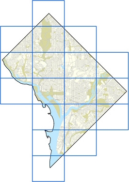
This map shows an approximate rendering of land use in the District of Columbia as it existed in 2005. This map is different from the Comprehensive Plan - Future Land Use Map, which shows land use as envisioned in DC’s 2006 revised Comprehensive Plan. The categories used in the two maps are similar, but not identical.
The Office of Planning compiled this draft from a variety of sources. The main data source was “use code” information from the Office of Tax and Revenue (OTR). An automated process assigned entire squares (blocks) to particular land uses when the use codes for the properties on those squares were consistent with one another. For squares with a mix of uses (e.g. a mix of residential and commercial properties) operators at OP split the areas manually until the remaining portions had consistent land uses. OP’s planners then reviewed this information and made corrections where the available data appeared inaccurate. Note that lot-by-lot property boundary information was far from complete when this work was performed, and was not used.
Click on the index map below to view 11” x 17” sections of the original over-sized map. Each section is presented as a separate document in PDF format*. To print this information on smaller paper, use the Adobe Acrobat Reader to shrink the page to fit, or use its graphics select tool to choose a portion of the page to print. Many printers also allow the user to tile 11" x 17" maps onto pairs of 8.5" x 11" pages. Colors on this map indicate types of land use (residential, commercial, public, etc.) and the intensity of use (high density, medium density, low density, etc.) that typically occur within each area.
This map has no legal status and is intended primarily as a resource and informational tool. The Office of Planning anticipates replicating this work over time, using better techniques as better information becomes available.
Existing Land Use Index Map

- Existing Land Use Map 01
- Existing Land Use Map 02
- Existing Land Use Map 03
- Existing Land Use Map 04
- Existing Land Use Map 05
- Existing Land Use Map 06
- Existing Land Use Map 07
- Existing Land Use Map 08
- Existing Land Use Map 09
- Existing Land Use Map 10
- Existing Land Use Map 11
- Existing Land Use Map 12
- Existing Land Use Map 13
- Existing Land Use Map 14
- Existing Land Use Map 15
- Existing Land Use Map 16
- Existing Land Use Map 17
- Existing Land Use Map 18


