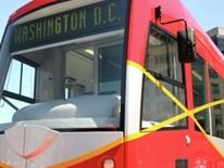
The District of Columbia is committed to bringing a streetcar system to the city to improve transit services available to residents and create walkable, vibrant communities. The District Department of Transportation (DDOT) is leading the system planning, design, financing and operations and construction of the streetcar and is moving forward with Phase I of the streetcar system with construction of the H Street/Benning Road line and the Anacostia Initial Line Segment. Please visit DC Streetcar for more information on the system planning.
Goals of the DC Streetcar System
-
Link neighborhoods with a modern, convenient and attractive transportation alternative.
-
Provide quality service to attract and reach new transit ridership.
-
Offer a broader range of transit options for District residents.
-
Reduce short inner-city auto trips, parking demand, traffic congestion and air pollution.
-
Encourage economic development and affordable housing options along streetcar corridors.
In the spring of 2010, the DC Office of Planning (OP) initiated a land planning study to ensure that the city and its residents gain the greatest possible benefits from the new system, and that the overarching vision and goals for the District are furthered by the new system. The Streetcar Land Use Study provides an assessment of the citywide benefits of the system in terms of access to jobs and schools, quality of life, transportation costs for households, job growth, and real estate market. The study also considers challenges of the introduction of streetcar service such as the impact on historic and cultural resources, housing costs and small business retention. The report examines the benefits and challenges along each proposed corridor and proposes alterations to phasing and small segments to maximize mobility and economic development of the investment.
The Streetcar Land Use Study serves as baseline information which OP, DDOT and other involved agencies may use to make recommendations regarding the District’s streetcar system. As DDOT completes system planning for each corridor, extensive public outreach to local residents and businesses will take place. Final decisions for the system will ultimately be subject to all applicable laws and regulations (such as a NEPA process).
Streetcar Land Use Study inquiries can be directed to Melissa Bird, Neighborhood Planning, at [email protected].
For information on system planning, phasing, construction or operations, please visit DC Streetcar or email [email protected].


